Due to the vagaries of internet access,
I'm writing this post in our room at Ayers Rock, but I won't be able
to post it for some time. (Ayers Rock itself is also called by its
Aboriginal name, Uluru. The resort is only called Ayers Rock Resort,
and the airport is Ayers Rock. So I'll use Ayers Rock for the whole
area, and Uluru for the rock itself, to make things easier, unless I
forget.) The Ayers Rock trip was late-ish June, about 23-25 or thereabouts.
First, before I try to explain exactly
what Ayers Rock is like, let me say that I think it is terrific. I am
thrilled that we came here. Why do I have to preface my comments with
that? Because the best word I can think of to describe the Ayers Rock
area is "weird," and I don't want you to take that the
wrong way.
Seriously, this place is sweet.
When humans finally get around to
building a colony on Mars, and I'm sure we can all agree that next
Tuesday would be convenient, I suspect it will look a lot like this
part of Australia. Not for nothing is this area nicknamed the "Red
Centre" - or "Red Center," if you spell Americanly.
The dirt is a deep bittersweet orange-red, the sort of baked
terracotta color they paint kitchens in remodeling shows if they are
going for a "Tuscan" vibe.
Airplane window shot of Kata Tjuta/ the Olgas, another rock formation near Uluru
There are only three types of kitchen remodels - "Tuscan," "Modern," and "Country." The Tuscan Red color will always be described as making the walls "pop."
Anyway, color is the first "weird"
part about Ayers Rock. It is as if you opened the landscape in
Photoshop and turned up all the saturation. Witness this unedited photograph, which demonstrates our excellent camera's befuddled attempt to make sense of the landscape:
The image processor is going to need therapy.
The sky is varying shades
of pure, clear blue, from a pale white-blue at the horizon to a
super-saturated warm blue directly overhead. The clouds, when they
happen, are clean white. The dirt is richly iron red, which means of
course that so are your shoes, your pant legs, and the ankles of your
socks.
Right next to Uluru
Did you know hunting boomerangs are thrown at the knees? It makes much more sense than impaling, which is how I assumed it worked. I would never survive in the wild.
The resort is practical about this, and has made the
comforters, carpets, and exterior paint of four-wheel drive vehicles
the same red color to save on cleaning.
Note Martian tin awning.
And then there are the many unexpected
shades of green. Part of why the green is so extraordinary, I'm sure,
is that the contrasting red strengthens my perception of the color.
(One could even say the red soil makes the green plants "pop."
Oh, I went there.) But the green is also objectively clear and
diverse. There are whitish greens, yellowish greens, grayish greens,
bluish greens, brownish greens, jade greens, and forest greens, and
then the sun moves one degree in the sky and suddenly everything is a
brand new color.
Pre-dawn
Dawn
NAAAAAAAAAAAAAAANTS INGONYAAAAAAAMA
I didn't expect this much plant life in the Outback
in general, and what plant life I did expect, I thought would be
scrubbier and more brown/yellow, like in the American Southwest.
Base of Uluru
I'LL GROW HERE IF I WANT TO
When you're from the city, or even a
forested rural area, distances in the desert are also perplexing. The
way I gauge distance is by taking an item of known size, like a stop
sign, pine tree, or two-story house, and using its apparent size from
where I'm standing. That doesn't work at all in the desert, where
there are basically no known quantities to use as points of
reference. The Ayers Rock resort area has one stop sign. The same
species of tree can be one foot or twenty feet high, depending on
whether or not that particular tree's location is affected by wind or
water.
Sunset. Not pictured: Useful frame of reference
Uluru itself is impossible to process,
size-wise. The statistics say that Uluru is 5.8 miles in circumference and 1,148 feet high (about 1/5 of a mile). The part of Uluru that is visible is actually just the tip of a giant underground rock monolith perhaps up to six kilometers deep. Think of it like a desert iceberg. Rockberg.
Not that big, right? Except THE DOTS ARE PEOPLE.
I just can't make these units meaningful, because how many things do you see in your daily
life that are measured in miles, or kilometers? The largest modern
unit of measurement which I can process easily is the football field,
which is approximately 100 yards/100 meters. I suppose I could tell
myself that the visible part of Uluru is the length of 360 football fields
end-to-end, but nobody ever sees anything like that.
The end result of all of this is that
when you're standing on a ridge looking at Uluru, you think, "That
could be a twenty minute drive, maybe?" Then your bus takes you
twenty minutes closer, and the size hasn't really changed at all, so
you think, "Okay, twenty more minutes then." And five
minutes later you're standing right up against the wall, and there's
nothing left to do but scratch your head and go with it.
Uluru from land, ~20 minute drive
Uluru from plane. LARGER?????
Even if you memorized the appearance of
Uluru from various points of reference, you'd still struggle to get
around because the landscape rises and falls so strongly that you
often lose track of the mountain. Coming from Ohio, where you can see
the capital skyline on the horizon from an hour outside the city, I
expected that the desert would also be flat. Not so! The undulating
ridges at Ayers Rock can vary by fifteen or twenty feet in height. If
you stood in the wrong places, you wouldn't know that Ayers Rock had
a rock at all.
Peek-a-boo! Where's Uluru?
There it is!
Color, distance... what else is odd
here? Oh. Temperature. It is winter, and I will confess to having
been inadequately prepared for what that means. I sort of imagined it
like winter in Malta, where a sweatshirt was comfortable for daytime
and you could throw on a scarf at night. Nope! In June, Ayers Rock is
cold cold cold, especially when you spend most of your time
outdoors, and often not moving much. During our stay, we had highs in
the 20s Celcius and lows around or just below zero. In Fahrenheit
terms, that's... I don't know. Highs in the 60s and low around 28?
I had a hood and scarf on about 30 seconds before this photo was taken, but for some reason I felt I would look better with my hair uncovered.
A few hours later, I just gave up. You decide on the hair thing.
Even that conversion doesn't really
help, because at the sun plays such a strong role in how the
temperature is perceived. Here is a handy chart:
Pre-sunrise: Wear everything you own,
in layers. Minimum of four is recommended.
Just after sunrise: Mysteriously colder
than pre-sunrise. Wear everything you own, and try to acquire pieces
from someone else.
Roughly 8 AM to 3 PM, direct sunlight:
You'll be fine in a t-shirt, as long as it's black.
Roughly 8 AM to 3 PM, shade: Continue
to wear at <3 layers, but you may take off your hat.
Evening: Put your hat back on.
Roughly thirty seconds after sunset:
Temperature plummets. Lose feeling in fingers and toes. Shivering
wildly will not help, but it will make you feel more productive.
Pre-midnight, i.e. for stargazing: Wrap
up in borrowed hotel blanket. That's why it's red! Cover your face if
possible, with a scarf or balaclava. (Note: Not suitable for
airports). You need to keep your fingers dextrous enough to operate
the hotel room key, which requires the devil's bargain of sticking
them on your own stomach. Give up on your feet, as you will not be
feeling them again until mid-day tomorrow.
So I've been deeply cold for most of our time at Ayers Rock. But really glad we came - it has been fascinating to experience a corner of Earth that is so profoundly different from anywhere I've ever been.
So enough about eating and drinking in Nara - what did Nana and I actually see?
Most tourists visit Nara as a day trip from nearby Kyoto, but we were so enthralled by Kyoto that we didn't make it out to Nara last fall. I'm a little sorry we didn't - Nara must have looked spectacular with the leaves turning. It was still a beautiful town when we visited, on a humid early summer day. I'd like to go back if we get to Kansai again: I feel like we barely scratched the surface on our morning walking tour.
Nara was the capital of Japan for most of the 8th century, an era referred to as (wait for it) the Nara Period, during which time Nara was actually known as Heijo-kyo, because nothing is simple in Japan. This period saw the first major wave of Chinese influence in Japan: kanji (Japanese writing in Chinese characters) and Japanese Buddhism were both imported from China during these years.
In fact, Heijo-kyo itself was modeled on Chang-an, the contemporary capital of the Tang Dynasty in China. (Chang-an is modern-day Xian, home of Qin Shi Huang's Terracotta Army, which Nana and I visited a couple years back.) Much of the old city plan has been replaced with Nara's modern streets, but the sprawling city park, Nara Koen, preserves most of the old temple district at the foot of the mountains to the east. The park itself encompasses all but one of the eight locations comprising the Historic Monuments of Ancient Nara UNESCO World Heritage Site.
To see Nara Koen, we took a free walking tour organized by Ryokan Matsumae, the little inn where we stayed the night. The volunteer guide was very friendly - eager to show off his hometown and to practice his English.
Our first stop was Kofuku-ji temple, on the western edge of the park. We approached from the south, for a view across the pond to Kofuku-ji's famous five-story pagoda.
The smaller three-storied pagoda on the western edge of the temple.
Kofuku-ji's famous eight-sided hall.
Kofuku-ji's five-story pagoda, one of the tallest in Japan.
Pagodas are built to hold sacred Buddhist relics; they're descendants of the stupa used in India & Southeast Asia. This one is said to hold a pinch of Buddha's ashes.
After Kofuku-ji, we stopped briefly at a viewing platform atop the municipal building at the edge of the park.
Looking west, towards central Nara.
Looking east, with Todai-ji on the left.
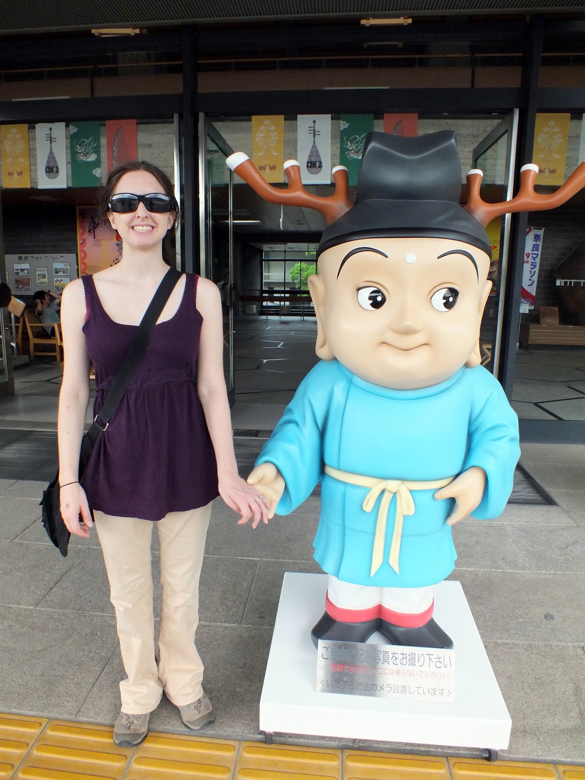
The Nara city mascot is a holy Shinto priest with deer antlers.
Suddenly, deer.
Nara Koen, you see, is full of deer, who in Japan are traditionally seen as messengers of the gods. Tourists can make offerings to the deer in the form of little rice crackers sold by vendors throughout the park. The deer have absolutely no fear of humans, and can be really pushy if you have food, or anything that vaguely looks or smells like food.
Naturally, this being Japan, the warning signs are pathetically cute.
Our next stop was the crown jewel of Nara Koen: Todai-ji, whose Daibutsu hall is generally regarded as the largest wooden building in the world. (Some argue that a few modern wooden buildings don't count, as they use a lot of metal joints and such.)
It's really big - and the original was even bigger!
"Daibutsu" means "big Buddha," and the Daibutsu hall is, in fact, home to a giant bronze Buddha.
Peace, dude.
Oh, wait, that was actually the little big Buddha, next to the big Buddha.
There we go. The dimensions are tough to grasp here. Each finger is a bit bigger than a full-grown man.
The Todai-ji complex is packed with national treasures, any one of which would make a lesser temple famous in its own right.
Like this Chinese-style bronze lantern from the Nara Period.
Or any of the several spectacular temple guardians.
For each of these, the shinbone is about the size of a typical adult.
I was particularly charmed by this worn wooden statue of a revered Todai-ji monk.
Situated just outside the entrance to the main hall, the statue is purported to have healing powers: touch the spot on the monk where it hurts, then touch the same spot on yourself while saying a prayer. Not surprisingly, the monk has very worn knees.
And a wonderfully expressive face.
But for children and the young at heart, the highlight of Todai-ji is probably the Buddha's Nostril Pillar.
The hole through the pillar is the same dimensions as the big Buddha's nostril. Supposedly, each trip through the nostril makes you wiser. Nana decided she needed some wisdom; I was obviously wise enough.
(Note: E-mail readers should click through to the blog for the video.)
Very gracefully done.
After Todai-ji, we walked up the hill to the much quieter Nigatsu-do (literally, "February pavilion"), an outlying structure of the larger Todai-ji complex.
Nigatsu-do is home to Nara's Shuni-e festival, a fire festival held in the second month of the year. During the festival, Buddhist monks circle the temple with a huge torch, then light the hillside behind the complex on fire.
Big torches.
An even bigger torch.
Being touched by the sparks or ashes from the torch is supposed to bring good fortune.
Stone tablets commemorating those who have donated to the temple.
A totally awesome chicken. Just because.
\In the off-season, Nigatsu-do is primarily known for its pleasant hillside location and its fine views over the rest of the park and the town.
We finished our morning's tour with a slow stroll through the wooded areas of the park.
Threatened to rain all day, but never really did.
Oh, yeah - the Nara Museum, apparently imported directly from Dresden.


